USDOT Thriving Communities Program: Roanoke, VA
15 minutes Date Launched/Enacted: Apr 24, 2025 Date Published: April 24, 2025

About the Thriving Communities Program (TCP)
The Thriving Communities Program (TCP) funds tailored technical assistance to under-resourced and disadvantaged communities, helping them better access historic infrastructure investments and deliver transformative projects. The USDOT FY 2022 Thriving Communities Program supports 64 communities across the country with access to a team of capacity builders to develop innovative community engagement methods, identify funding opportunities, and grow long-term capacity to develop and deliver transportation projects that strengthen communities.
TCP Complete Neighborhoods Community of Practice
TCP Communities are grouped into three Communities of Practice: Main Streets, Networked Communities, and Complete Neighborhoods. The 15 communities included under the Complete Neighborhoods Community of Practice are:
| Atlantic Beach, SC | Isabela, PR | Santa Cruz, CA |
| Billings, MT | Lansing, MI | St. Louis County, MO |
| Decatur, IL | Lima, OH | Suffolk, NY |
| East Orange, NJ | Providence, RI | Sumter, SC |
| Indianapolis, IN | Roanoke, VA | Waukegan, IL |
The US Department of Transportation (USDOT) selected a capacity building team led by RMI, including: the American Council for Energy-Efficient Economy (ACEEE), Equitable Cities, Nelson\Nygaard, and the Shared-Use Mobility Center (SUMC), to provide technical assistance to these 15 communities.

A Snapshot of Roanoke, Virginia
Roanoke, Virginia is an independent city located in southwestern Virginia in the Blue Ridge Mountains. The city’s population (97,171 according to ACS data 2024) makes Roanoke the largest city in southwestern Virginia and the economic hub of the region. Roanoke’s median household income is $48,476, significantly lower than the state ($80,615) and national median household income ($74,580). Black or African American residents make up 28.6% of Roanoke’s population, and 6.7% of residents are Hispanic.
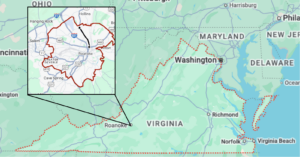
Location of Roanoke within the State of Virginia Credit: Google Maps.
Key Initiatives for Transportation
Roanoke has been working towards Envision Williamson Road through TCP. Envision Williamson Road is focused on addressing safety improvements on Williamson Road.
Williamson Road:
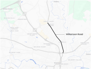
Williamson Road is located in the northern part of Roanoke, stretching from Downtown Roanoke north to the city limits. The Williamson Road corridor is made up of several neighborhoods, but is thought of by residents and city officials as a cohesive area because of the recognizable corridor that runs throughout. The area includes the Roanoke-Blacksburg Regional Airport, the Roanoke Civic Center, several commercial and industrial clusters, and diverse residential areas. The corridor’s 6.5 square miles constitute 15% of Roanoke’s land area, and nearly 14,000 persons live along Williamson Road, representing 15% of the city’s population. The Virginia Department of Transportation (VDOT) highlighted Williamson Road as an area with safety concerns and high numbers of crashes.
A 2022 Virginia Department of Transportation (VDOT) study reported 389 crashes between 2015 and 2019, including 12 pedestrian crashes—two of which were fatal—and one bicycle crash. Today, Williamson Road is not only a vital transportation corridor but also a cultural hub, home to a growing Spanish-speaking community and one of the region’s two census tracts designated as historically disadvantaged. These safety and economic challenges make the revitalization of Williamson Road essential for the community’s well-being and its economic success.
Williamson Road. Credit: SUMC

Williamson Road highlighted in cyan from Route 460 (Orange Avenue) to Route 101 (Hershberger Road). Credit: Project Pipeline Virginia Secretary of Transportation.
Through the Thriving Communities Program’s technical assistance, Roanoke focuses on addressing a three-mile stretch of the road from Route 460 (Orange Avenue) to Route 101 (Hershberger Road), shown in the above map.
The draft of Roanoke’s City Plan 2040 recognizes that some of Williamson Road’s challenges began decades ago, citing “chronic vacancies and blight” dating back to the 1970s. While past plans, such as the 2004 Williamson Road Area Plan, have identified key issues and potential solutions, significant intervention is required to reverse the area’s decline – as even then, up to 16% of land in the corridor was vacant. The Virginia Department of Transportation has also highlighted the corridor as a safety concern and initiated studies to propose design improvements to reduce crash rates and enhance pedestrian and cyclist safety. Additionally, past engagement efforts, such as the 2022 Project Pipeline study, lacked meaningful input from the local community, particularly the Spanish-speaking population and organizations with strong ties to the area.
Envision Williamson Road
The Envision Williamson Road project is the main focus of Roanoke’s TCP work. Through Envision Williamson Road, the City of Roanoke seeks to address safety challenges through authentic, consensus-driven community engagement. This initiative focuses on Williamson Road from Route 460 (Orange Avenue) to Route 101 (Hershberger Road). The project aims to implement targeted safety improvements and foster an environment conducive to economic revitalization by combining technical expertise and genuine public participation. Ultimately, this effort aspires to transform Williamson Road into a safer, more connected, and thriving corridor for all who live, work, and travel.

Attendees walk along Williamson Road during the TCP walking tour in April 2024. Note the utility pole on the sidewalk, the narrow sidewalk, and how close cars are parked to the sidewalk. Credit: The City of Roanoke.
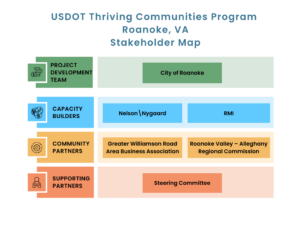
Stakeholder Map. Credit: SUMC
Activities through the Thriving Communities Program
To develop a workplan, the Capacity Builder team led an in-depth needs assessment with the City of Roanoke to learn about the community’s primary challenges, capacity gaps, ongoing relevant plans and projects (like Roanoke’s Smart Scale application and VDOT study of Williamson Road and Roanoke’s City Plan 2040), and relationships with local CBOs.
The needs assessment for Williamson Road identified several key challenges and areas for improvement. Limited prior engagement efforts and a lack of outreach to the corridor’s non-English-speaking community were significant gaps. Concerns about increased congestion and a lack of awareness of the benefits of multimodal connectivity further complicated efforts, which resulted in opposition to the formerly proposed project , with a “No Road Diet” campaign. Additionally, the cost estimate of the previously-proposed project proved to be prohibitively high, since it exceeded the funding available through Virginia Smart Scale grants.
The identified technical assistance needs include project engineering support, tactical urbanism pilots, direct engagement with neighborhoods and businesses (especially those outside the business association), exploring funding opportunities, and improving traffic safety.
To address the challenges identified on Williamson Road, the Thriving Communities Program team conducted a needs assessment and developed a work plan. Efforts in the work plan included:
- Create a Vision: Visioning and community engagement
- Review Choices: Introduce safety countermeasures
- Select options: Gather feedback from the community and recommend countermeasures for Williamson Road
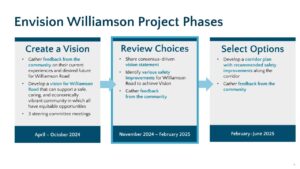
Envision Williamson Project Phases. Credit: Nelson\Nygaard
Create a Vision
The first phase of Thriving Communities work was focused on community engagement to eventually create a vision for the future of the Williamson Road corridor.
The Thriving Communities team created a community engagement strategy for the effort, centered around forming a steering committee of key community stakeholders. Four steering committee meetings have been held to date, with more planned for 2025.
- Steering Committee Meeting 1 (April 2024) kicked off the project. Attendees shared their experiences on Williamson Road and the Thriving Communities team designed a walk audit along the corridor.
- Steering Committee Meeting 2 (July 2024) introduced a community survey, provided a recap of engagement held to date, and asked steering committee members what additional groups the City of Roanoke should reach out to.
- Steering Committee Meeting 3 (September 2024) introduced crash data from the Roanoke Vision Zero project (ongoing).
- Steering Committee Meeting 4 (November 2024) was focused on creating a vision, with the Thriving Communities team leading activities to generate a vision. After visioning exercises, the Thriving Communities team introduced safety countermeasures.

Dwayne D’Ardenne from Roanoke speaks at the Envision Williamson Steering Committee meeting. Credit: The City of Roanoke.
Throughout Phase 1, the City of Roanoke has been hosting community engagement events, including presentations at neighborhood meetings, advocacy groups, and the Greater Williamson Road Area Business Association; tabling at major Williamson Road festivals; door-to-door conversations and flyering for businesses; and an online survey that received over 500 comments. Key takeaways from participants’ input and engagement boards are shown below. The first set of boards was used at pop-up and tabling events at festivals. The boards asked community members to rate the quality and safety of various aspects of Williamson Road, such as comfort, look of the area, quality of driver behavior, sidewalks, and street crossings.

Envision Williamson Engagement Boards. Credit: Nelson\Nygaard.
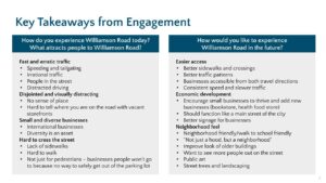
Key Takeaways from Envision Williamson Engagement. Credit: Nelson\Nygaard.
Visioning Exercise for Envision Williamson Road. Credit: Nelson\Nygaard.

Envision Williamson Frequently Asked Questions. Credit: City of Roanoke.
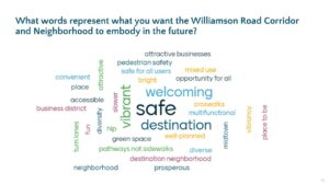
Phase 1 wrapped up in November 2024 with Steering Committee 4. Steering committee members provided words that represented what they wanted Williamson Road to embody in the future. Steering committee members also provided feedback on the City of Roanoke’s overall vision to signify what words could be used in a Roanoke vision. The vision developed through Envision Williamson Road is “Williamson Road: A vibrant multinational business and residential community that creates, connects, and supports sustainable, safe, and accessible destinations.”
Review Choices
The second phase of technical assistance is focused on (1) introducing proven safety countermeasures and alternatives and (2) receiving community feedback on proposed alternatives to improve road safety. Using the USDOT’s proven safety countermeasures, the Capacity Builder team identified improvements that would reduce speeding, improve the pedestrian and bicyclist environment, and improve safety on Williamson Road. The Capacity Builder team illustrated four alternative concepts for a X mile section of Williams Road. A slide shared at Steering Committee Meeting 5 (January 2025) outlines the four alternatives. Two alternatives (A1 and A2) maintain the road in its four-lane configuration (two lanes each direction) and two alternatives (B1 and B2) presented a three-lane configuration with one lane in each direction with a center turn lane or median. The alternatives were evaluated by their impact on road user safety, vehicular access, multimodal access, cost, feasibility, and policy adherence (Roanoke’s Complete Streets policy and Safety Action Plan).

Proven Safety Countermeasures For Williamson Road. Credit: FHWA and Nelson\Nygaard.

Alternatives reviewed at Steering Committee 5. Credit: Nelson\Nygaard
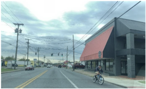
A bicyclist bikes in the opposite direction of traffic on Williamson Road. Credit: Nelson\Nygaard.
Select Options
Williamson Road is on Roanoke’s paving schedule for 2025. Given this, the City has an opportunity to implement a six month pilot to “test” the effectiveness of one of the preferred alternative concepts. This pilot will also serve as a final engagement phasel for Envision Williamson Road, which will extend beyond the Thriving Communities Program. Steering committee members participated in an exercise at Steering Committee Meeting 5 (January 2025) to review the alternative concepts for a pilot and selected a preliminary alternative to pilot. The alternative selected was B1, a 3-lane interim, lane reconfiguration approach. This alternative will have three vehicle lanes (one vehicle lane in each direction and one center two-way left-turn vehicle lane with un-protected bike lanes adjacent to the curb).. Roanoke project leaders will go back to neighborhood groups and to City Council in Spring 2025 to share this preferred alternative and proposed approach for the pilot. The pilot is expected to begin in Summer 2025. Throughout the pilot, the City will collect data measuring effectiveness of the new lane reconfiguration. After the six month pilot, City staff will reconvene the Steering Committee to review the outcomes of the pilot and decide whether or not to advance a permanent three-lane configuration. After the Steering Committee makes a selection, the City will repave the road and mark the lanes according to the preferred approach.
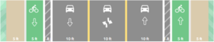
B1 three-lane road configuration chosen for a six-month pilot. Credit: Nelson\Nygaard.
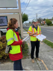
Ian Coffey from the City of Roanoke leads a group during the TCP walking tour in April 2024. Credit: The City of Roanoke.
Key Partners
Roanoke is working with several key partners on these initiatives. Some of these partners include:
Greater Williamson Road Area Business Association: The Greater Williamson Road Area Business Association represents businesses along the Williamson Road Corridor and was supportive of previous improvement plans (although some individual businesses were not). The association will be a key partner in ensuring engagement with the full range of business owners.
Roanoke Valley – Alleghany Regional Commission: The Roanoke Valley – Alleghany Regional Commission is the Planning District Commission for the Roanoke area and provides some transportation planning assistance.
Steering Committee members include:
- Roanoke Library Foundation
- Greater Oakland Neighborhood
- Airlee Court Neighborhood Watch
- Roanoke Arts Commission
- Blue Ridge Independent Living Center
- James Breckenridge Middle School
- Preston Park Elementary School
- Virginia Department of Transportation
- Roanoke City Public Schools
- Greater Roanoke Transit Corporation/Valley Metro
- Williamson Road Community Forum
- Greater Grandview Neighborhood
- Blue Ridge Literacy
- Williamson Road Library
- Williamson Road Business Forum
- Virginia Department for the Blind and Vision Impaired
- Old Mountain Road Neighborhood
Related Resources
Capacity building efforts through the Thriving Communities Program are continuing until May 2025. The Capacity Builder team will conduct more technical assistance activities and will update this case study as the program progresses.