Technological Advancements and Interagency Networks in Central Ohio: COTA’s AI-enabled Transit and Traffic Management Platform
20 minutes Author: Shared-Use Mobility Center Date Launched/Enacted: May 1, 2022 Date Published: March 20, 2024
Summary
- In 2020, the Central Ohio Transit Authority (COTA) received an Integrated Mobility Innovation (IMI) grant from the Federal Transit Administration (FTA) to launch an interjurisdictional transit and traffic management platform
- COTA’s platform, launched for internal users in May 2022, ingests data from sources including transit agencies, public safety and emergency services, and local governments across a 13-county area.
- This platform helps COTA and its partners monitor traffic incidents, dynamically reroute vehicles in response to acute issues, and improve service planning through AI and machine learning technology.
- Though there is no specific plan for the future of this platform, there are many possibilities. This project represents how new technologies and interagency partnerships can intersect to improve regional transportation.

This pilot project is part of the Mobility Innovation Collaborative (MIC). The MIC provides a comprehensive suite of technical assistance resources, promotes knowledge sharing activities, and captures stories and lessons learned from innovative mobility projects across the United States.
Originally published March 2024, revised June 2025.
Description: Video interview with JR Clairsinvil, Product Manager at the Central Ohio Transit Authority (COTA) Credit: Shared-Use Mobility Center (SUMC)
Introduction
Local governments, transit agencies, and mobility providers are constantly pursuing new and innovative technologies to improve the safety, efficiency, and accessibility of transportation services. While these advancements can propel the transportation industry forward, new technology is just one piece of a complex puzzle, and meaningful progress occurs only when these tools can converge with coordination, communication, and cooperation from stakeholders.
In 2020, the Central Ohio Transit Authority (COTA), the transit agency serving the Columbus metropolitan area, received a grant through the Federal Transit Administration (FTA) Integrated Mobility Innovation (IMI) program to launch a connected mobility platform that gathers transportation data from a variety of sources and allows for predictive analytics using artificial intelligence (AI) technology. This platform works to improve traffic management, transit service, and road safety, and is built on the coordination of transit agencies, emergency responders, and other governmental services across 13 counties in the region. This project rests at the intersection of technological advancement and interagency collaboration, ensuring that new tools can work to improve service, safety, and efficiency for all partners.
History of the Project
In late 2015, the US Department of Transportation (USDOT) launched its Smart City Challenge by asking cities across the country to develop innovative ideas for integrated, data- and technology-driven systems that help improve transportation, quality of life, economic growth, and access to jobs. Columbus’s application identified a variety of potential initiatives to deliver enhanced human services to people in the region, and was ultimately selected as a finalist to work further with USDOT to develop these ideas. Among Columbus’ Smart Cities initiatives was a connected mobility and traffic management platform, which would allow transit agencies, emergency services, mobility providers, and planners across the region to view, share, and react to real-time traffic and emergency information through a single source. This web-based platform began as a way to overcome silos between agencies in the central Ohio region operating in different jurisdictions, and aimed to improve interagency coordination, reduce congestion, enhance road safety, and improve agency operations generally.
Furthering the work done through Smart Cities, COTA applied for a grant through the FTA’s IMI program that would go towards the development and implementation of this platform, and was awarded $1,750,000. As a condition of receiving the federal grant, at least 20% of the budget was required to be a local match, and COTA contributed an additional $800,000.
To build the platform, COTA selected Waycare Technologies, which was acquired by Rekor Systems in August 2021. Rekor is a software company specializing in AI solutions employed to collect and analyze mobility data. The agency-facing platform was rolled out to internal users across the region starting in May 2022.
Operations
COTA’s traffic and transit management platform uses AI technology and machine learning to analyze large amounts of data and relay relevant information to COTA. The platform’s main interface features a live interactive map of the area, shown in the image below.
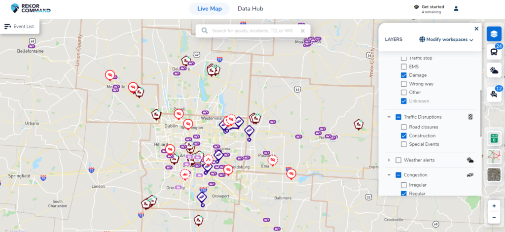
Screenshot of the Map Dashboard showing various incidents, cameras, maintenance workers, and other features. Credit: COTA
The user can select from a variety of filters to highlight (or hide) specific information on incidents, congestion, weather conditions, service vehicles, and more. Some of these filters include:
- Counties. Each of the counties involved in the project is included. This allows platform users to focus on a particular service area, rather than the entire region.
- Incidents and events, including stalled or abandoned vehicles, crashes, debris, police or fire activity, and others.
- Traffic disruptions, which include road closures, construction, or special events.
- Extreme weather alerts. This filter displays polygons on the map to show areas affected by floods, heavy fog, tornados, and other potential hazardous conditions.
- Traffic congestion. This option highlights areas that have particularly high levels of traffic.
- Units or vehicles. When activated, this filter displays the city police, highway police, fire department vehicles, ambulances, snow plows, street sweepers, and other vehicles tracked by the platform.
For a detailed look into the nature of an incident, or for status information for a vehicle, a user can select that icon on the map, and a window will appear with more details.
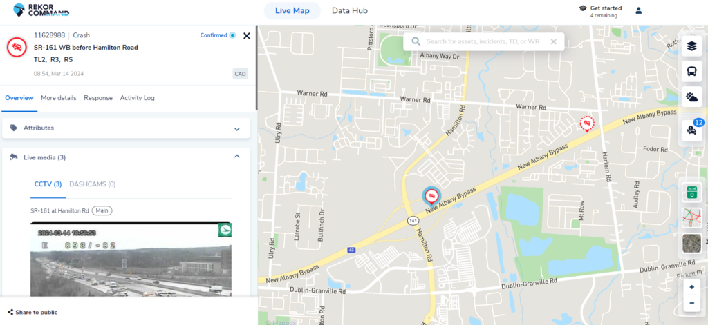
Screenshot of the Map Dashboard showing details of an incident. Credit: COTA
Platform users can also view details of fixed route buses or on-demand services.
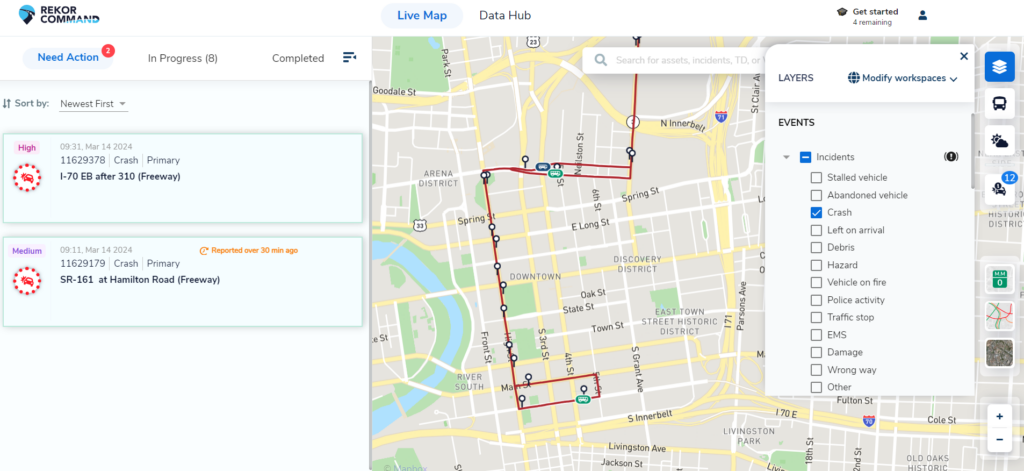
Screenshot of the Map Dashboard showing details of a fixed route service and incidents nearby. Credit: COTA
Additionally, the platform hosts dashboards for transit analysis and incident analysis that users can use to generate reports to inform future planning. For example, a user could use the transit analysis dashboard to create a report on the number and frequency of paratransit trips across county lines, and use that data to inform on how to best accommodate travelers moving between jurisdictions. Similarly, a user could use the incident analysis dashboard to examine data on incidents for a particular roadway to determine how to direct improvements.
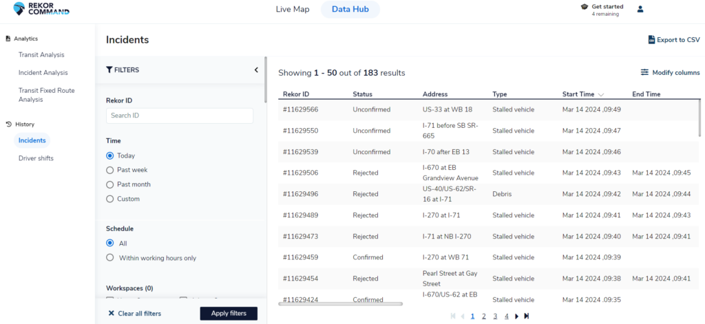
Screenshot of the Analysis Dashboard. Credit: COTA
The data used in the platform comes from a variety of sources, mostly from existing infrastructure. While this information may have previously been siloed at various separate agencies, the dashboard acts as a space to access all of it, increasing the value of any given data source by placing it in a wider regional context alongside other agencies’ information. Some of these data sources include:
- General Transit Feed Specification (GTFS), the standard data format for public transportation which indicates vehicle schedules and status. Most transit agencies that operate fixed-route service use GTFS to track their vehicles, and public-facing applications like Google Maps or Transit use GTFS data to provide easily digestible information to riders. COTA’s platform also uses GTFS-Realtime (GTFS-RT), an extension to GTFS which also shares immediate vehicle locations, arrival time predictions, and alerts.
- Computer Aided Dispatch (CAD), a system used most often by emergency dispatchers to collect incident information and dispatch responders. When a 911 caller reports an accident to a dispatcher, the CAD system can collect relevant data related to the incident, like the nature of the incident, caller information, the location of the incident, or locations of responders. This project allows the locations of the incident from this data to make its way into the COTA’s platform so that the agency’s Traffic Operator Specialist can see the locations of accidents. That Traffic Operator Specialist then relays information to COTA’s dispatcher to reroute buses accordingly.
- Automatic Vehicle Location (AVL), a method of tracking fleet vehicle location data. AVL is a tool often used by government agencies to track and manage their fleets. For this project, COTA receives AVL data from all participating partner counties with a transit agency.
- Roadside cameras which display a live feed video of vehicle traffic at various locations. The traffic cameras in Columbus are owned by either the Ohio Department of Transportation (ODOT) or the City of Columbus. This project allows COTA to access some of the camera feeds in the region, which may provide additional information in the case of an incident. The video feeds are not recorded, but the platform user can screenshot images if necessary. For example, in the case of an accident involving a COTA bus, images from the camera feed can be easily accessed through the platform, screenshotted, and forwarded to the relevant departments so COTA can more effectively investigate the incident and have a clearer idea of what safety or legal actions to take.
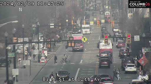
Image from an ODOT roadside camera. Credit: ODOT
With all the data in one location, COTA has access to real-time information on every accident, road block, event-related traffic jam, extreme weather event, or other incident that could impact transit service in the entire 13-county area. With detailed real-time data, the COTA operations team can communicate important information directly with bus drivers, customers, or if needed, emergency responders. For example, if COTA anticipates that a bus will be delayed due to a car accident ahead on its route, the agency can easily reroute the bus to avoid any slowdowns, inform any customers that would be impacted of the change and potential alternative options, and monitor the situation to be able to return to regular service as soon as possible. Previously, a bus driver encountering this situation would need to navigate road closures on their own. COTA can now use the platform to efficiently tackle rerouting in real-time, allowing the agency to operate proactively when it comes to service delays, rather than reactively.
In addition to being able to monitor services across jurisdictions and dynamically reroute vehicles, the platform helps COTA and other partner agencies be more proactive in planning. COTA is able to collect large amounts of data and analyze that information to inform better allocation of resources. This is aided by AI and machine learning technology, which helps analyze the immense amount of data to survey traffic patterns and detect anomalies. Through the analytics dashboards, the platform can build predictions over time to illustrate a clearer picture of how, when, and where accidents occur. For instance, the platform can analyze transportation patterns over a long period of time and determine that crashes are more likely to happen along certain corridors in accordance with large gatherings like concerts or sporting events. COTA and the City of Columbus could use this analysis to predetermine alternative routing for transit before such events, pre-position emergency services to facilitate a quick response, and be ready to communicate changes to customers and across other agencies that might be using the corridor. The map dashboard also includes a map layer for crash risk, so users can easily visualize this analysis. Ultimately, the predictive analyses powered by this project allow agencies and emergency services a better understanding of how to allocate resources, enhancing transit service and public safety.
Planning
The 13-county region covered by COTA’s platform extends far beyond COTA’s service area, and this project is built on cross-agency collaboration. This project requires the participation of transportation and emergency services in various jurisdictions, and starting early in the process, COTA encountered challenges getting all partners on board. The project was an unproven concept, and there was a great deal of uncertainty to what it could achieve. COTA had to spend time and effort to demonstrate what benefits the platform could bring to stakeholders from jurisdictions that stretched from the core of the urban area to fully rural, with a corresponding range of technological and staff capacities. However, these efforts eventually paid off and COTA was able to get their stakeholders engaged in the project. Franklin County, where Columbus is located, and Union County, northwest of Columbus, were the first partners to get involved.
Once COTA was able to overcome the hurdle of getting all partners in agreement to participate, the agency still faced a complicated contracting process. For the platform to work, local agencies working with varying technology vendors had to provide COTA access to their data. When agencies allow another entity, like COTA, to access this data, they are generally required to pay a fee to their technology vendor to make the necessary updates or extend licensing to allow for the data sharing. COTA was able to cover these fees, but this required contracts with each county to disburse funding. At the same time, COTA’s legal and data teams had to develop contracts with each county, each agency, and each service provider to cover the terms of data sharing and usage. Each data sharing agreement uniquely specified what information should be shared, how that information could be used, the time period of the data sharing, and other stipulations. Furthermore, if COTA were to expand or revise its data usage at any point, new agreements would need to be drafted and signed. Because of the large number of involved partners, the data procurement became a long and arduous process. Despite this, COTA and its partners continued to recognize the value this platform could offer, and were patient throughout the process.
The partners currently involved in this project are:
- Delaware County
- Licking County
- Knox County
- Union County
- Pickaway County
- Fairfield County
- City of Westerville
- City of Columbus
- Traffic Management Center of Columbus
- Division of Fire of Columbus
- ODOT
- Ohio State University
Goals
COTA’s primary goal for the project was to improve interagency coordination and overcome silos between jurisdictions. This platform allows better data transparency among previously siloed agencies and emergency services, even within the same local jurisdictions. Access to this data not only helps each agency refine their operations individually, but can assist with planning more effectively for interjurisdictional transportation.
Improving roadway safety was another major objective for this project, complementing Vision Zero Columbus, the city’s action plan to eliminate traffic injuries and fatalities. By increasing access to information about roadway conditions and monitoring incidents in real time, the platform can help transit agencies and emergency services respond more quickly to incidents, direct emergency resources more effectively, and ultimately reduce crashes.
Another goal was to broadly enhance regional transit. The platform helps monitor and analyze transit performance, which can impact planning for both fixed-route and on-demand services. With the analytical tools developed as part of this project, COTA and its partners can improve operational efficiency and on-time vehicle performance.
Challenges and Lessons Learned
The project’s efficacy relies on the collaboration of different transit agencies, mobility providers, emergency services including fire and police departments, city services, and private partners. With such a diversity of partners, the biggest barrier COTA faced was coordinating with all stakeholders and ensuring that every agency could see the value in the project. As mentioned previously, an integrated, AI-enabled transportation management platform operating at this scale was a largely unproven concept. The first major lesson learned for COTA was the value of collaboration. Early on in the process, it was imperative to break down silos and get all the stakeholders on board. Thorough interagency communication and collaboration was necessary both to ensure partners could see the value in the project, and to help inform the direction of the work to make it useful for each partner agency.
Demonstrating the value of the platform was a particular issue for smaller transit agencies in the area. Since many of these small agencies do not operate fixed-route services, they have less use for all of the platform’s features. Partner agencies operating only demand-response van services in low-density service areas can “dynamically reroute” vehicles easily enough—via radio dispatch, phone call, or the operator’s discretion—without any additional technological support. Often, these agencies have Global Positioning System (GPS) tools onboard their vehicles, which automatically present an alternative route to a driver if an incident were to occur. Thus, transmitting accident information to operation centers is more consequential for larger agencies. COTA, for instance, is the largest agency in the region, and operates fixed-route, demand response, and on-demand services in a mostly urban environment, factors that make this platform especially beneficial.
COTA understood that to foster collaboration, it was necessary to recognize that each partner had its own goals and priorities, and different agencies’ priorities might not always align. The project team’s being open to partners’ concerns and willing to explore solutions helped to get partners invested. For instance, while smaller transit agencies did not see the value in some of the rerouting capabilities of the platform, they realized that they could benefit from the platform’s analytical tools. These tools allow agencies to see trip metrics for demand-response services, which can assist in more efficient scheduling and vehicle distribution. This information can be leveraged to help transportation planners and mobility managers provide better service to riders over a longer time period. Additionally, being able to track the frequency of trips across county lines was particularly useful for small agencies, as they could better manage and allocate funding for paratransit and non-emergency medical transportation trips. These benefits were not initially clear to small agencies, but became more apparent as partners collaborated and communicated as the project evolved.
Additionally, different agencies have different technical capacities. While COTA and other larger transit agencies had been using more advanced booking and dispatching technologies for their on-demand or demand-responsive services for some time, some of the rural agencies involved in the project were still tracking trips for dial-a-ride services with pen and paper. Making the platform usable for all partners required COTA to carefully consider where each partner agency was coming from as a first step to determining how to move forward. This was not only an important step in the collaborative process, but also helped highlight some of the broader limitations and capacity mismatches that can hinder large cross-agency collaborative efforts. Strong partnership building requires careful attention to all partners’ capabilities and priorities.
Future Plans
COTA is still determining whether it will continue to support the platform beyond the IMI program. Once IMI grant funding is exhausted, the maintenance and operations required to continue the platform would be funded completely by COTA and be housed under COTA’s Innovation department.
Though there are no specific plans for the future of the project, there are many opportunities, both for scaling COTA’s platform and for wider adoption. Many of the platform’s features are built on AI technology, which has proliferated rapidly in recent years throughout many industries. The transportation sector in particular is still exploring ways to benefit from these new developments, and future iterations of COTA’s platform could refine data analytics, dynamic routing, or other platform features as AI technology improves.
Regardless of whether or in what form COTA continues the project, it will likely never develop into a public-facing product. Currently, this application collects and analyzes large amounts of data from police departments, fire departments, and emergency medical services. Since much of this data is personal information, COTA wants to be careful about opening any opportunity for malicious parties to access it through a public-facing platform.
Conclusion
COTA’s transit and traffic management platform highlights how technological advancements can impact transportation planning and emergency management. Using predictive analytics and large amounts of data from many different sources, the platform helps COTA and its partners act proactively rather than reactively, improving transportation service and safety throughout the region.
While the cornerstone of COTA’s IMI project is the AI and machine learning technology, interagency cooperation was essential to propel the project forward. COTA had to break silos and foster collaboration between transit agencies, local governments, mobility providers, and emergency services in a 13-county region extending beyond COTA’s own service area. Coordinating with so many partners who have different priorities, goals, and capabilities can be a difficult endeavor, but forming these solid partnerships is necessary to advance innovative transportation projects.
Key Considerations for developing an interagency transit and traffic management platform
- What is the scope of your project? How many different agencies, municipalities, and mobility providers will be involved?
- What do you plan to gain from a dynamic data analysis tool like this, and what will other cooperating agencies gain? How can this improve safety or service planning and how will you ensure you get the most benefit from it?
- What strategies do you have to build partnerships with many different entities? What existing relationships do you have and how can you leverage them?
- Data sharing agreements can take a lot of time and effort; what do your legal and data teams need to be prepared?
- What are your technology and software requirements? What are your agency’s capabilities to meet those requirements? How can your technology vendor(s) address them?
- How else can transit agencies benefit from interagency and interjurisdictional cooperation? How else can partnership building improve mobility services beyond this technology?
For more information and a live demonstration of COTA’s transit and traffic management platform, see the recap for the Second Mobility Innovation Collaborative Workshop.